Tuesday, August 27, 2024
Queen's Park Neighborhood in New Westminster

Tuesday, May 05, 2020
We'll Need to Update the 10-Year Plan
At the moment, we're in an unusual situation because of the COVID-19 pandemic. It's hard to plan ahead when we're not sure what's ahead. Another complicating factor, is we're not exactly sure where we would like to head for November 2020 through April 2021. We have a lot of ideas!

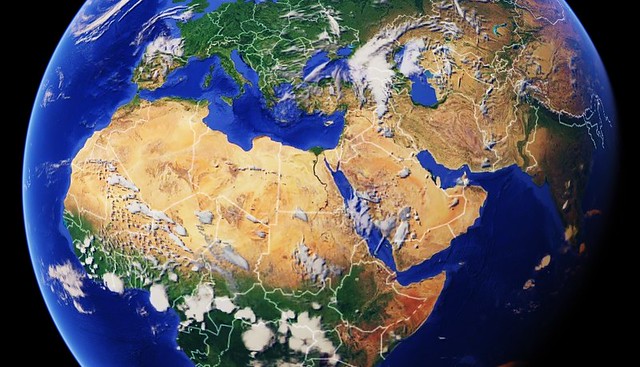
I love that Google Earth now runs in most browsers. It's an amazing tool.
Five years ago, in the middle of our first early retirement winter in Puerto Vallarta, I wrote a blog post using the label, Our 10-Year Plan. In it, I put three locations on a list for a possible renewed visit. Guess, what? We have already wintered in those places. It'd be easy to fall into a routine; however, the world is big and our time in it fleeting. New chapters in life are often written by those with imagination, drive, and a lot of wanderlust.
It is definitely time to create a new list. Also, it'll be important to increase the number of years in our plan. More than five years of owning our own time have already passed in the seeming blink of an eye.
Thursday, April 09, 2015
Looking for the Nile - Day 134
As a kid I thought being able to draw and represent a piece of the world on paper was extraordinary. I learned that one could say things by using maps as a medium. I'd have much rather read an atlas than a story in junior high. I partially blame my wanderlust as a result of dreaming about places in the world first seen on a map.
Of course, I've said how awesome Google Maps is many times. I appreciate the company for search, but respect them more for figuring out how to show me the world inside my browser or app. It does seem that Google never rests. Inspiring technology like GPS navigation now seems old hat. Still, I can only imagine what features will materialize over the next few years. This is truly, amazing stuff.
I can start with an image from space and jump right down to street level. Something like this never existed even in the scifi from my youth. Unfortunately not all cities have been scoured by a Google van. In today's case, it is a shame. We are already in our research phase for where we'll spend next winter. It's interesting to see a place in context to the larger planet.

Click on the image above, and Google Maps will open in a new browser tab. Ensure that you are in "Earth Mode" to see as satellite images. Then, you may slowly use the + option to zoom in more closely. Each click will bring you closer and closer to the place we will rent. Hopefully, you'll land right in our future neighbourhood.
[NOTE FOR APP USERS: Google Maps generally defaults to showing the image in a medium-range view. You may try keeping the pin centered and pinch or un-pinch to see the location as it relates to a more intimate or more global view.]
Monday, June 03, 2013
Caring about Cartography
It's not the usual way of looking at North America, is it?
I have always loved maps. I partially credit Mr. Frank Hammond for sparking that interest. Frank taught us during junior-high and high school in Sunapee, NH. It might even be the case he used to come into elementary school classes when our all the town's students were housed in one building. Oh my, that place was the shining beacon on a hill, wasn't it? At least that will be the way I will always think of it.
Of course my love of cartography still exists, but no one in the early 1970's could've dreamt of something like Google Earth or Maps. We can now zoom in with any magnification and even drop into Street View in so many locations around the world. It really is amazing stuff and makes me rather happy I am alive in this Internet era.
It's been a while since I saw one of these though. Imagine 3-foot wall maps which cut most of the earth's landmass in two just to put the Americas in the middle of everything! I think I was always a little confused that India was on the right and the left.
Friday, June 03, 2011
For the Love of Geography
I quite often find myself in Google Earth or Street View. I love the way in which anyone can now explore the world. Much more than simply a map, the application environment is rapidly becoming an alternative way to browse. No longer limited to text, people are free to actually explore places via the screen.
When re-visiting the Cinque Terra in Italy, I came across a 360 degree photo. You know what I mean; it was one of those panoramas where you can use a pointing device to look around the complete image. I clicked and was reminded of one of the most stunning places I'd ever been.
Little did I know there are whole horde of hobbiests taking 360-degree panoramas. I clicked through to the website which hosted the image. I challenge you to attempt *not* spending time at this website!
Sunday, May 15, 2011
It's Amazing. It's Free.
It's amazing that it's free. I had been making due with Google Maps lately. It gives one access to the satellite information and Street View via the simple, browser interface. In fact I didn't even have a copy of Google Earth, its more complete cousin, on my most primary computer used at home. I had, of course, fallen in love with the power of the latter many times over the last five or six years.
I was running into the fact one cannot rotate within Maps. I wanted to face the shoreline and come it at a low angle, I realized I'd need to download version 6 of Earth should I want to do this. With each iteration, the program gets more and more powerful. One can hit a button and a sunlight slider appears which allows you to see how the present orientation will receive the day's light. There seems to be so much more packed into the application.
It is monumental software feats such as Earth which just rekindled my gratitude for Google as a company. If it were run by Microsoft it would still look like the 1990's. On the other hand, if it were owned by Apple then it would only be available via iTunes at $0.99 per view.
Friday, June 18, 2010
More of My Tracks
Yesterday, I drove home on a slightly different path. Although I'm teaching mornings now, when I try to commute home during rush hour, it is a whole lot faster to run up Royal Oak and slide along the midpoint of the hill. (You can see Royal Oak starting around kilomter 2.) I wanted to see how much father it is. As well as answering my question, it also provided this interesting graph. This shows the hill between the campus and home. The campus looks like it's on relatively low ground and the apartment is not far from sea level, here near the Fraser River. You can see that the graph is measured in meters, so I have to go over a hill that's over 320 feet.
My Tracks does a good job on highways but it's also designed to take along on hikes as well. How fun! Am I too old to decide I really like math a lot?
Wednesday, August 26, 2009
Must Pack Some Extra Cash
Earlier in the year, I was keenly interested in a particular apartment development near Negombo. I was even in regular email correspondance but the location lost its luster. There are a ton of different places to choose from all over the island but basically we're urban folks. Being far away from Colombo wouldn't be very satisfying during a long-term stay. And although I thoroughly enjoy the mountains of the up-country, they could be visited while having a home-base by the beach.
So, I looked on Internet real estate sites first to find places near Dehiwala / Mt. Lavinia. Many luxury places are far out of reach of our budget. I don't know why prices are so expensive when compared to similar dwellings in other places in the world. However, something like this would be fine.
Then, in order to get a perspective of its location and distance to other places, I dropped into Google Earth. Zooming around the area and checking out nearby services in Google Maps makes pre-investigation easy.

We probably won't even look around or inquire when in Sri Lanka from mid-September to mid-October. Still, I can always enjoy wasting a little time thinking about such things.
Tuesday, March 03, 2009
Not for Speculation Sake
I was able to confirm the exact location of the the apartment building construction which I blogged about last week. The location is conveniently close to the International airport and thus not far from the Negombo beaches. Unfortunately, if one zooms out on the map below, it is easy to note it's also quite close to the new airport-to-Colombo toll road. I'm sure the view of the lagoon is nice but I'd rather not while away my days counting traffic on such an idyllic island.
View Larger Map
We'll be heading to Sri Lanka for a month this autumn. Maybe we can use that time to look around. I suppose no right-minded person would get too excited by property seen on the Internet. One just cannot get the feel of a place from a picture or two.
Saturday, January 24, 2009
King Kasyapa (477 – 495 AD)
I wanted to see a satellite view. First, I zoomed to the location in Google Earth and saved in Google Maps for easy navigation. You can see the result here. Unfortunately, it hardly does it justice. I'd rather see the photos taken in 2004. Below is one photo of about twenty I have on Flickr.

Yesterday, I Facebooked a newly-discovered link for Sri Pada or Adam's Peak in Sri Lanka. Although we saw a great deal of the island on trips in 2004 and 2006, it is one famous site we missed. Should we travel there this autumn, it will be on the itinerary.
Monday, January 05, 2009
Sharing Exact Locations
I can't imagine a valid reason not to load Google Earth. I love the ability to fly to various places we've walked on the earth. I use it to plan trips before going and to see where we were after returning home. I knew there was a program option to view the exact same Google Earth screen in 'Google Maps'. I discovered that provides an easy way to send off a link to others.

For example, you can click the screen shot above to show an old section of Puerto Vallarta, Mexico often refereed to as the Romantic Zone. After it appears, you may zoom and move the satellite image. We only had a one-day stop over in that city on a Mexican cruise last February. I am sure I've got more than one Flickr picture online taken from that jetty seen near the top of the captured image above.
Puerto Vallarta might be a great place for a vacation week next month.
Thursday, August 21, 2008
In North America the Car is King
I patted myself on the back because I found relatively cheap tickets to Rome. Back in July, I mentioned about purchasing them online through Expedia. This was after becoming quite irritated that we could find no cheap flights from Vancouver. In fact, if we wanted to fly from Vancouver, a single ticket would've cost $1600! So, when I found round-trip tickets from Seattle for $820 per ticket, I snatched them up. Today on Expedia for the dates we chose, I found the cheapest tickets from Vancouver are now selling at $1820 each. Ouch!
I knew we would have additional expenses as well as inconvenience due to flying out of Seatac. Yet, we assumed even paying for Quick Shuttle bus tickets and hotel rooms, we'd still be saving hundreds of dollars.
I'd nearly made reservations at a cheap hotel adjoining the airport, when I decided to check out the availability of inexpensive, long-term parking near the airport. Wouldn't you know, it's cheaper to drive down and buy a month's parking at Seatac Park, than the bus tickets alone. Not to mention, the process is undoubtedly more convenient than crossing the border with a bus load of other passengers and not being able to stop to eat or shop.
I reserved a space for September 14th through October 5th. Driving down and parking is the easiest and cheapest way to get to the Seattle-Tacoma International Airport. That is a little ironic considering we're going to Europe where it's perfectly possible to get around on public transit.
Wednesday, August 13, 2008
Without Premeditation
I am sure I've hit on this topic before. Yet, when I found myself trying to find the location and photographs of specific hostels near the Roma Termini, I became acutely aware that I needed to create a reminder to myself.
Here goes.
I sort of wear the ability to travel without reservations as a badge of honour. I generally consider most Americans as travelling babies because they must plan out an itinerary down to the very last dot. Whereas, I have always assumed that all cities have people who are willing to feed and shelter me even if I show up unexpectly. If one travels in most of the old-world, it's easy to get to a main rail station. Generally, they're close to the centre of the cities. Around them, it's always possible to find the type of accommodation we prefer; namely, we're looking for cheap!
I'm beginning to realize my bravado has probably only come as a result of necessity. I first tasted international travel in the 1980's. Right out of college, I worked in Kuwait and began jetting about that decade. I don't think it was possible to plan out exact details even at a travel agent in those days. Some people joined tours when visiting. Yet, if one were on one's own there may not have been any other way to travel than by simply doing it.
Now that I've got the Internet at my disposal, I have to remember not to plan the spontaneity out of the travel. It's simply too easy to pre-book hostels and transportation reservations online. Then, one simply has no option but to follow the ill-conceived arrangements which were created prior to arrival.
No, it's much much better to play things by ear. I've got to remember that.
Saturday, May 31, 2008
Fly Around for the Weekend
View Larger Map
Google Maps is okay but I can, quite literally, spend hours playing in Google Earth. For example, I was contemplating retirement. Although I read in the newspapers how most boomers want to, or may need to, continue working past the traditional age of retirement, I'm sure I want to finish up at age 55. Or at least I want that option.
I've been thinking where it'd be nice to buy winter property. Recently in Phoenix, we were rubbing shoulders with Canadians trying to cash in on the real estate market troubles there. I am setting my sights a little further away. I'm more of a tropical than desert person. Maybe Mexico or even Sri Lanka would be possible.
Regardless, I can do more than think about these things with the software tools at my disposal. I can zoom right in on a neighbourhood in a flight of fancy.
Wednesday, April 30, 2008
Can You Dig It?
I don't know why I don't run into more people who are as enthusiastic as I am. I can check real places around the globe I've been. For example, after mentioning Yemen in an entry here the other day, I wondered about a military camp where I once worked. Jay and I met after I arrived at the Taif Army Ordinance Corp and School in Taif, Saudi Arabia. I located the area: 21 19' 08" N 40 26' 07" E. Obviously a lot of things will have changed since 1985/87!
I am probably more likely to use Google Earth when researching upcoming vacations. Being able to zoom right in on a specific address can be useful when checking for hotels or attractions. It seems great to see areas before visiting them. It's no longer necessary to physically be at a place in person to get the lay of the land. Which road shall we take to the southern rim of the Grand Canyon next month? I'm checking right now in another window, in fact.
Monday, January 14, 2008
I Don't Need No Stinkin' Taxi
Rather than the glitz of Hollywood, we're using Long Beach as our jump-on point for next month's Mexican cruise. Contrary to popular wisdom, it is possible to get around the LA area on transit. In fact, as we're flying down plenty early, we plan on getting from LAX to the Long Beach Carnival terminal by transit. I am so thankful for Google Earth so we can nearly try it out in advance ... virtually.
Wednesday, December 19, 2007
The Original Skid Row
Of course, we could simply drive somewhere close. Hotels are seldom busy as business travel has ceased and many folks are staying with family even if they are travelling. I can remember going to the nearly frozen Okanagan one Christmas. On others we went to visit friends or jumped on a ferry for Victoria. It's only Wednesday, so there are still a couple of days to make a final decision.
It may even be fun just to slide down to Seattle for a few nights. Discounting the wait at the border, it's only a leisurely three hour trip. If one's willing to stay cheap, it's possible to find, because of the season, a hotel within walking distance to downtown for only $60 per night. In order to see the city where the term skid row was coined, I fired up Google Earth. I was first awed by the program in October 2005 and since then it's continued to grow and develop. It doesn't often get the press it deserves but for those of us who like geography it's truly a miracle.
Sunday, April 08, 2007
Satellites & Vacation Planning
The screen capture above shows the Los Angeles area from 50 miles up. Nearly all the amazing extras overlays were turned off. Our hotel is located in the center of the large image at the mouse cursor. In the upper-right corner, I added a view of the hotel at nearer street level. I could recognize it from the outdoor swimming pool.
Saturday, February 03, 2007
Finding 2301 Brown Avenue
In fact, I cannot imagine why a single computer with Internet access wouldn't have Google Earth loaded. Now at version 4, it seems to be getting better and better. You can easily fly around the entire world for free!

Next weekend, we're going by real airplane to Manchester, New Hampshire. My dad seems to be doing fairly well in a rehab hospital there. On the phone, he sounds as though he's made a great deal of progress in the last month. Although still occasionally confused, he is looking forward to seeing me. I'm very glad I waited to fly out. I believe it's good that he's been able to count down the days to my visit. In the image above, I found the location of the Super 8 near the airport where we'll stay. If we travelled more upscale, we wouldn't be able to travel around so far and so often.
I haven't been in Manchester since I was a kid. It's about 50 miles from my hometown of Sunapee and about halfway to Boston, Massachusetts. My family used to frequently drive to Manchester to go shopping. Those were in the days before much in the way of shopping was available in Claremont or West Lebanon, NH.
Thursday, October 26, 2006
Not a Time Machine
I was recently admiring satellite views of the world through Google Earth. Back when personal computers were new and I worked overseas, I used to collect pirated software. In the Gulf, in the eighties, there were no avenues to purchase authentic copies. I was reminded of a very early program I once used. A company called BlueSky Software once created IBM-compatible software called PC Globe.
I came up nearly empty on the Internet. I only discovered a bit about the company and the titles they produced but very little about when the specific piece of software in question was released. What I really want to see is a view of the, then state-of-the-art, CGA graphics that it boasted. Suddenly I remembered, I could double check on PC Globe by looking at my Software Games from 1989 pdf. Unfortunately, the 5 1/4 inch bendable floppy disc I was thinking about is not listed there at all.
It's a bit sad to think that something created within the last twenty years can vanish so completely. This is especially poignant as computers are what the Internet is all about. I've been unsuccessful in my search. Please drop me a line if you know anything about BlueSky's PC Globe. I volunteer to be a resource and will even write up an entry for Wikipedia!
Today, it's possible to even zoom in on the very neighbourhood where I grew up. I'm 5,000 kilometers from that location and maybe that adds to the romanticism of being able to look where my feet trod over 45 years ago.